Bikefast wanted to know what the peak rates of everyday cycling were in our city. We’ve talked a good bit about the perceived growth of cycling in our city and we’ve posted lots of encouraging pictures to Instagram – but we’re struggling to get good, granular data out of our Transport Department (DfI). So we took matters into our own hands. We pitched our intrepid bicycle counter (me – Ed) at three locations along the Laganside corridor on evenings in Autumn 2016 and Spring 2017 to get just a little sample of what a dedicated cordon count might show.
In the second of three articles, we take a look at Belfast’s Albert Bridge, at it’s intersection with the National Cycle Network..
Count 2: Albert Bridge (west bank)
This is a complex junction as East Bridge Street meets the Albert Bridge. Heavy arterial vehicle flow between East Belfast and the city centre interacts with roadway entry and exit points on Laganbank Road and at Maysfield – although both are restricted to with-flow movement by a central reservation. A pedestrian crossing sits between these and the bridge.
High pedestrian footfall is generated by the office blocks which have sprouted up over the last 15 years around Central Station – the region’s busiest railway station. On the east bank of the Lagan the dense communities of the Short Strand, Lower Ravenhill, Woodstock and The Mount power a strong tidal pedestrian commute.
The National Cycle Network (Route 9) through Belfast crosses East Bridge Street at this western end of the Albert Bridge.
The data
Placing a video camera on a large Dutch bicycle we recorded two separate periods of the evening rush hour – one in October 2016 and one in May 2017. Both days had clear weather and no major traffic incidents were reported – just normal working weekdays.
Going bicycle crazy down here at Belfast's Albert Bridge #cyclingrevolution pic.twitter.com/nwDtSGrAsp
— NI Greenways (@nigreenways) October 6, 2016
We noted the direction of bicycle travel and some characteristics of the riders (more on that later).
Over the two days we observed a total of 328 bicycle movements in a combined 84 minutes, giving the Albert Bridge an estimated peak flow rate of 236 bicycles per hour, or about 4 bicycles per minute. It’s not The Netherlands, but for Belfast this is pretty cool. The rate is almost identical to the nearby Gasworks Junction we studied in part one.
We’ve worked up a graphic to demonstrate the flow patterns.
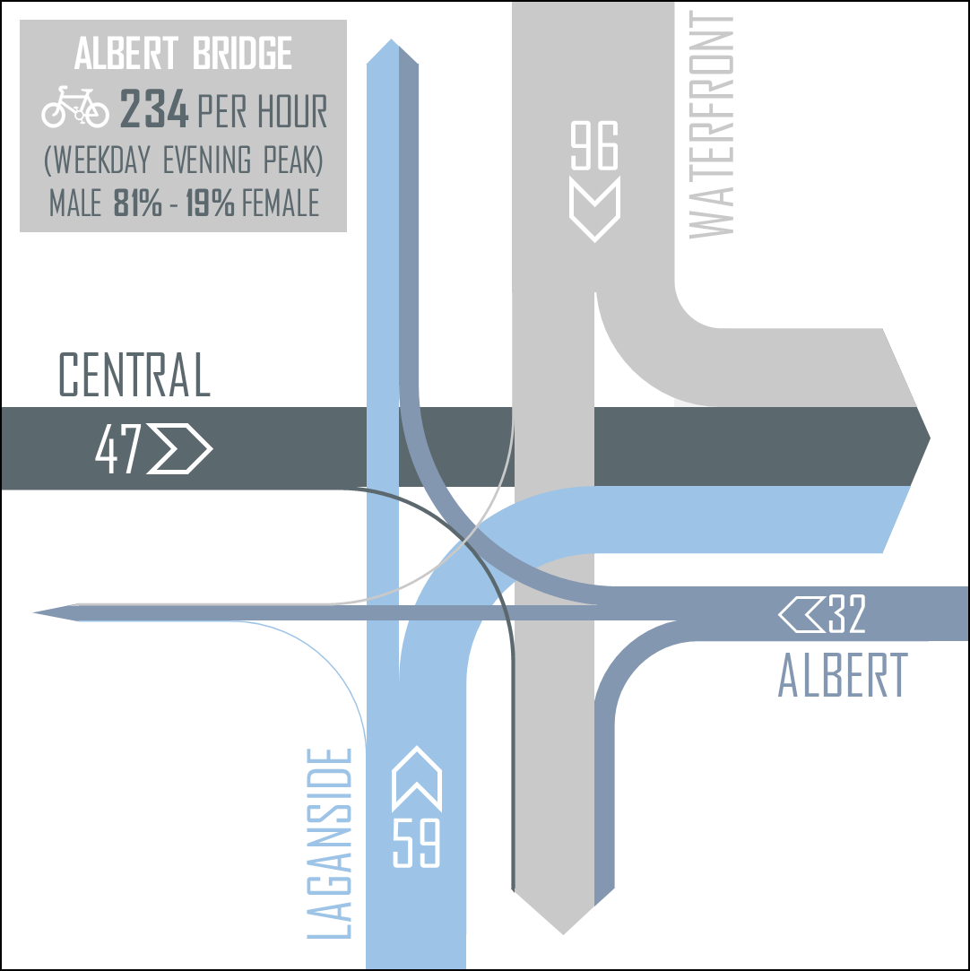
Those cycling from the Waterfront direction accounted for 41% of journeys entering the junction while 56% of people exiting the junction were travelling east across the Albert Bridge.
Naturally for an evening rush hour, very little cycling traffic is headed towards the city centre, which lacks a dense resident population – interestingly Deliveroo riders provided a large proportion of those who were travelling that way.
As with the Gasworks there is a clear gender imbalance with 19% of those cycling being female. It’s an indication that Belfast still has a long way to go to make cycling safe and accessible for everyone.
Footway or roadway?
One aspect of the Albert Bridge which has troubled road engineers and campaigners alike is the perception of a hostile roadspace for those cycling. The tall concrete and metal vehicle restraint barriers on both sides of the four lane roadway hem you in, giving no “escape route” to the footway.
The Cycling Unit (and their predecessors) have shared anecdotal observations that about 50% of people cycling on the bridge do so on the footways rather than take to the road.
So with our handy dataset, we decided to clarify the situation a little – and Bikefast has found the majority of people cycling on the Albert Bridge use the footways, closer to 60% of all movements (in both directions):
- 18% of people cycling used the northern footway
- 42% of people cycling used the road
- 40% of people cycling used the southern footway
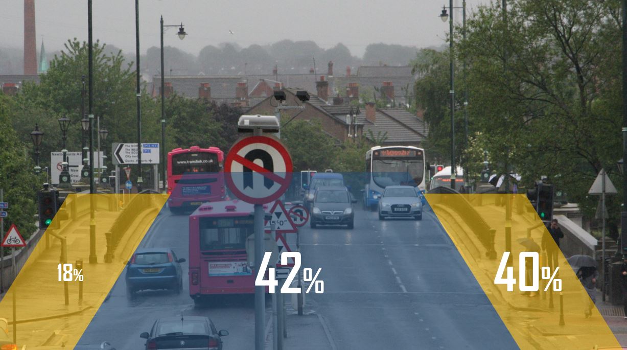
The footways are too narrow at rush hour to accommodate high pedestrian footfall and a significant volume of bicycles. It’s an indication of a sick road environment – unforgiving, unwelcoming and unattractive to those using bicycles. And it poses difficulty for pedestrians.
While building a bridge at the Gasworks will divert some cycling journeys off the Albert Bridge, the general growth of cycling which will follow the adoption of Belfast Bicycle Network Plan requires some form of cycling adaptation here. Bikefast’s Restitching Belfast series proposed fitting additional pedestrian walkways on the outside of the bridge platform, allowing the current footways to be converted to dedicated cycleways.
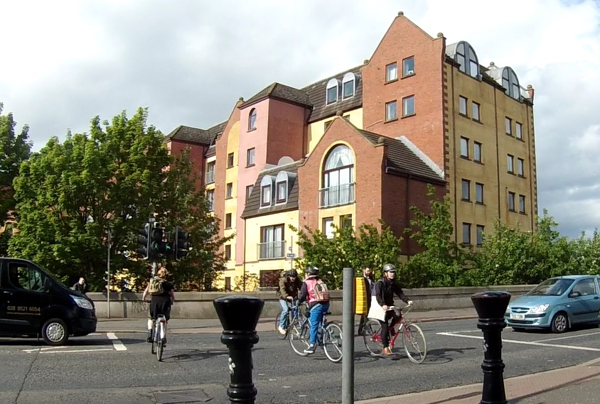
Even though this section of the city was familiar to Bikefast, the level of bicycle usage was surprisingly high, especially heading away from the National Cycle Network. It adds weight to Bikefast’s view that future cycling infrastructure development must not ignore the main arterial routes of the city.
In our final article on the Lagan Cordon Count series we will look at the Ormeau Bridge – will our data bear out its long-assumed title as the top cycling junction in the country?
Why are we doing this?
Other than being curious about the impact of the Cycling Revolution™ which, apart from some infrastructure, is still a purely organic movement in Belfast, we’re trying to highlight a big gap in government data gathering and everyday cycling insight.
Our best indication of cycling growth is at a very high level. We have the annual Travel Survey for Northern Ireland which places cycling commuting (not everyday journeys) at between 3-5% of all commuter journeys in the city.
Other than that, the Census is our most detailed look at cycling habits, but again only looks at commuting – and we’re about halfway between the 10 year gap between Census reports.
We used to have a potentially excellent source for cycling journey data – the (now defunct) Department for Regional Development’s live cycle counters. These enabled the Department (now DfI) to measure growth on key corridors.

And then they were turned off. And many were removed. The boxes may still be in place but nothing is happening inside.
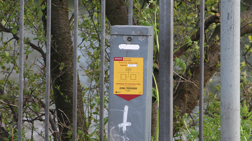
We’re calling for DfI to deploy new live cycle counters in a cordon around the city to enable the growth of cycling, linked to their proposed Belfast Bicycle Network Plan, to accurately measure cycling journey levels and observe demand for new facilities.
And we need a baseline before those cycleways are built, so counters should be going in now. And to top it all off, live roadside counter displays should be deployed in a couple of locations to demonstrate to everyone that cycling is an important and growing part of our city’s transport landscape.


