Bikefast’s official consultation response to the Draft Belfast Bicycle Network Plan consists of four articles laying out our objections to the document.
Objection three deals with the three radial routes. Bikefast has made a strong case that route selection for the Draft Belfast Bicycle Network Plan should be methodical and not left to emotive arguments or a popularity contest. However ring routes are ring routes and there’s not too many options to play with in Belfast. In Bikefast’s view a few amendments are required to potentially transform cross-city transport.
Outer ring
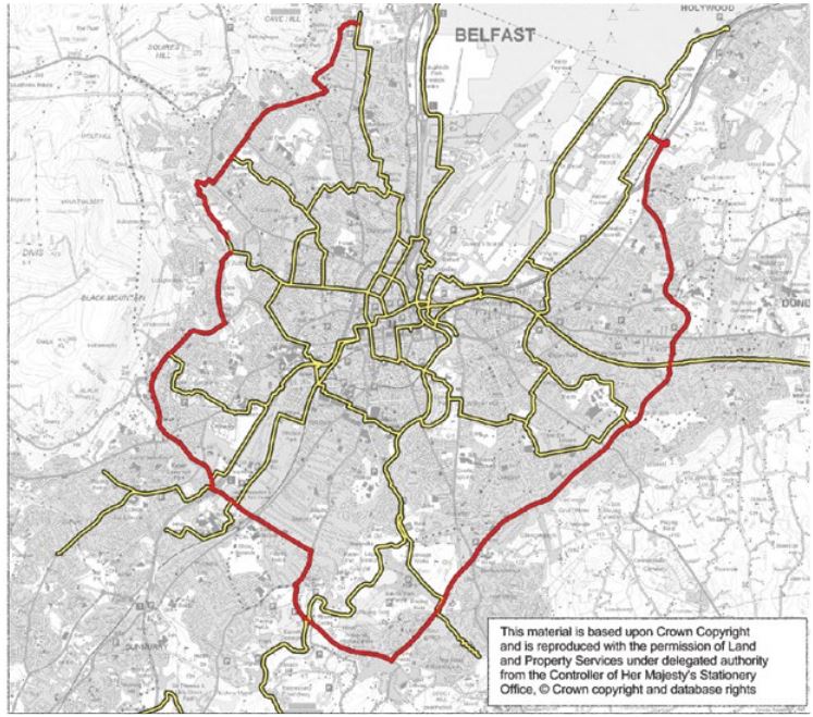
Excellent work here by the Cycling Unit who nailed this aspect of the Plan. The Cycling outer ring unashamedly runs along the existing A55 (vehicle) outer ring of the city. Many areas already have cycling space of varying standards, but there’s lots of space to play with around the entire 27.8km route.

Draft Belfast Bicycl Network Plan outer ring proposal – spot on
The outer ring must continue to play a strong, perhaps enhanced, role for traffic management if cycling within this cordon is to thrive.
Traffic volume and speed dictates that cycling facilities along the length will be of the highest quality, not the compromise we have now.
One minor suggestion would be to incorporate the Giant’s Park Bridge idea from the Restitching Belfast series, which could extend the outer ring in North Belfast across the railway, motorway and into the fast-developing new employment and leisure quarter of Belfast.
Middle ring
While the outer ring is critical for circulation of all traffic, the informal middle ring of Belfast is contested space. The Cycling Unit have also allowed themselves (and their route) to be diverted by the Connswater Greenway in East Belfast, going against the natural grain of this important ring route for active travel.
In many ways this middle ring (as used by traffic today) shouldn’t exist. The quickest way from Park Centre to Forestside is Tates Avenue – Eglantine Avenue – Chlorine Gardens – Ridgeway Street – Sunnyside Street/Annadale Avenue – and it’s completely inappropriate for large numbers of vehicles. But through the years little cut-throughs and rat-runs have become established thoroughfares for vehicles and the city has adapted accordingly.

Informal Belfast middle ring – Chlorine Gardens and Dundela Avenue the daftest bits
The eastward extension of this is Sunnyside Street/Annadale Embankment – Mount Merrion – Ladas Drive – Grand Parade – North Road – Dundela Avenue – Holywood Road, again relying on streets (Dundela Avenue in particular) that it’s almost shameful to consider the traffic we permit to plough through.
The Cycling Unit have attempted to devise a similar middle cordon around the whole city for the bicycle network.

Draft Belfast Bicycle Network Plan middle ring proposal
We have minor suggestions for alternatives in North and West Belfast, although the Grosvenor / Springfield Road corridor should be treated as a full arterial route in its own right and a cycling route extended from city centre to the outer ring.
It’s when the middle ring reaches South and East Belfast that Bikefast feels the Cycling Unit have really missed a trick.
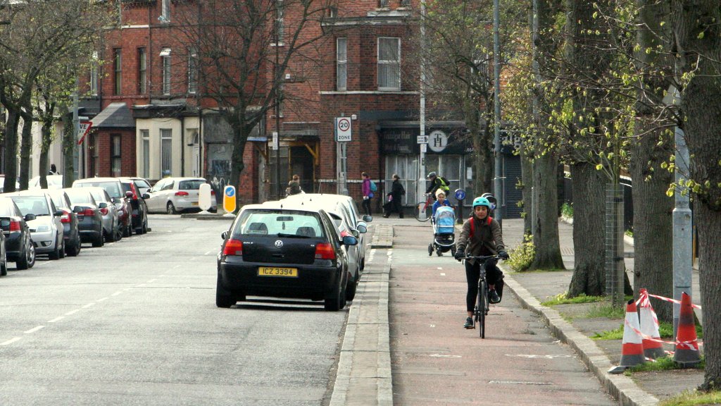
For a start, the existing dedicated cycleway along Park Road has been ignored, instead of being extended right up to the Ravenhill Road.

Dedicated cycleway along half of Park Road – should be extended
From here the NI Greenways proposal to cut the one-way rat-run of Ravenhill Park/Onslow Parade to create two traffic-calmed two-way streets snipped to through-traffic at the Kingspan Stadium should have been preferred.

How to eliminate a major rat run and make a cheap addition to the Cycling Network
Then comes an ideal opportunity to roll out a Dutch-style roundabout on the Cregagh Road – to rein in what is a hideously fast double lane nightmare for pedestrians and bicycle users.

Model of how the Cregagh Road roundabout could be calmed and people-prioritised
To this point the Cycling Unit have been going across the Ormeau Park (nice), Ardenlee Avenue (far more troublesome than Ravenhill Park) and arriving at Ladas Drive via Gibson Park Avenue.
This is where Bikefast expected the Cycling Unit’s vision to match ours – utilising the wide spaces and direct middle ring corridor of Ladas Drive – Grand Parade – North Road – Dundela Avenue to the Belmont Road.
But they got distracted by the excellent Connswater Greenway. This is problematic for a number of reasons.
- The natural pattern of the middle ring is already established. This bicycle ring takes users away from this route of high demand. As with the problem of ignoring arterial roads, the Cycling Unit are back to expecting people to change their travel patterns to suit the plan, not planning routes to suit users’ needs.
- It’s a shared path, with children’s playparks alongside. As the greenway approaches the Castlereagh Road the boardwalk is a tight 2.5m bounded by fencing, which is unsuitable for two-way cycling plus sharing with large volume of pedestrians.
- The death knell for the idea – a gate has been installed at the Castlereagh Road entrance. Ladas Drive and Grand Parade don’t have gates for traffic. Bicycle users shouldn’t be diverted to routes where this is likely to happen. That alone scraps this unnecessary diversion.
Anyone spot the problem for @deptinfra who want to run their strategic city bicycle network thru here instead of Ladas Drive / Grand Parade? pic.twitter.com/4dihdjopcA
— NI Greenways (@nigreenways) April 12, 2017
The Connswater Greenway is already a transformative leisure and utility linear park, but it should not have large numbers of faster commuter and through-journey cyclists funnelled down its narrow shared paths – especially if the only reason is that we aren’t confident enough as a city to take away road space from motor vehicles.
Arrogance of space – a two lane street (middle ring road) where cycling infra *is not planned* as part of Belfast's future cycling network pic.twitter.com/4DNV7mxbp2
— NI Greenways (@nigreenways) April 5, 2017
We should be building dense, better cycling networks to support trips to and from our excellent greenways, not using them to tick a box and say “job done, cycling catered for”.

Bikefast’s proposed middle ring route
Part of the reason why these routes have become so critical for car travel is the lack or orbital bus routes – perhaps a legacy of the Troubles. One advantage of this for cycling is the lack of competition for space from bus lanes.
But there is a more fundamental question – what damage does the volume of vehicle traffic around these streets do to the neighbourhoods they plough through? In planning for a healthier city, shouldn’t we prioritise pedestrian and cycling movements on these corridors, but critically look for ways to push vehicle journeys to the more capable A55?
If we leave a pleasant route for vehicles to circulate within the city, which gets you to your destination quicker than the more appropriate outer ring, you’re not encouraging active travel enough. If you then plan your bicycle route to go around the houses to avoid upsetting this vehicle route, you’re doing this all wrong.
A short history of traffic engineering, via @copenhagenize. Directness is so important for walking, biking & transit. pic.twitter.com/nSPOBVT6Z6
— Brent Toderian (@BrentToderian) February 17, 2014
The middle ring needs a big rethink, and not just where the bicycle network routing is concerned. There must be separated cycleways on the existing road network and avoiding the inappropriate Connswater Greenway diversion.
With no circulating bus services people really only have two choices for non-walkable journeys here – the car or the bicycle.
The vehicular traffic using these middle routes must be assessed and a plan devised to push more of the through-journeys onto the A55 outer ring. That means road widths tightened, more zebra crossings, junction capacities reduced, perhaps some through access snipped.
This way the middle ring can become one of the most critical corridors for active travel in Belfast, not this afterthought.
Inner ring
This is where Bikefast’s vision deviates the most from what the Cycling Unit have presented. The inner ring in Belfast is the subject of many plans for how the streetscape should be prioritised – from the Urban Motorway plans of the 1960s which would have devastated the city, to the more people-focused plans of today, which still largely hinge on maintaining the flow and volume of vehicle traffic around the city centre core.
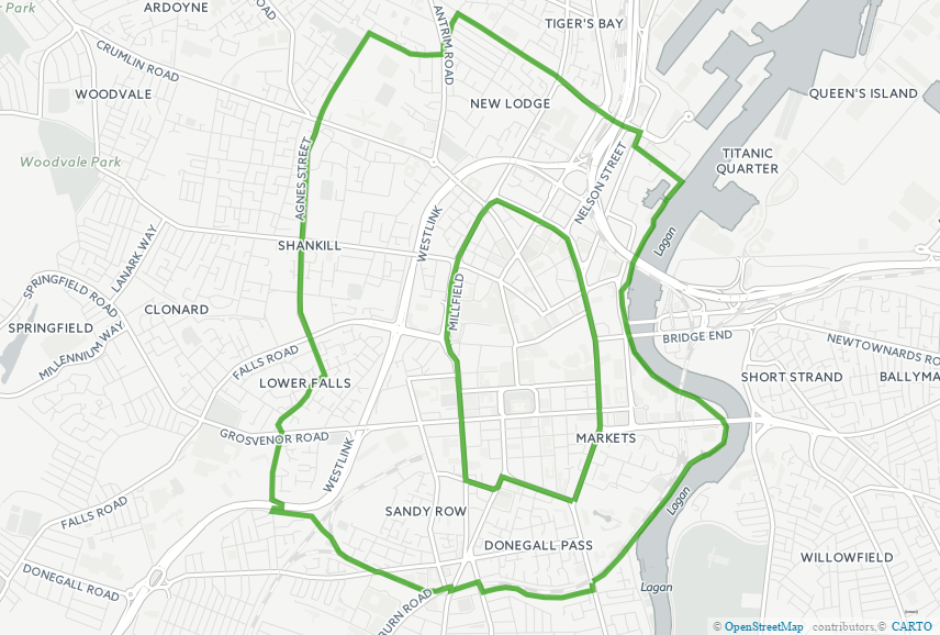
For the most part the Cycling Unit have planned a route as expected for two-thirds of the natural (vehicle) inner ring, but on the eastern edge of the city centre there is an unnecessary diversion. This heads out to the existing Laganside facilities which are too far from the natural orbit of the city centre.

Draft Belfast Bicycle Network Plan inner ring proposal
From Ormeau Avenue to Cromac Street, going on to Victoria Street and the Dunbar Link is a deadly racetrack where cycling is virtually impossible. This is where the cycling inner ring needs to flow, and to allow two-way movements to make the bicycle more attractive where vehicles are restricted to northbound travel only.
This is especially crucial for the new Ulster University Campus as the most direct line from the Holylands to Buoy Park is along this corridor – a luxury afforded to cars but not planned for bicycles – a mistake of priorities.
Victoria Street is something of an urban motorway – almost completely devoid of street frontage and life, so clogged with fast vehicle traffic as the width of the road expands from 3 lanes to as many as six past Waring Street. Returning people in place of a few cars would be a worthy outcome of this plan if it builds upon the small section of cycleway already there.
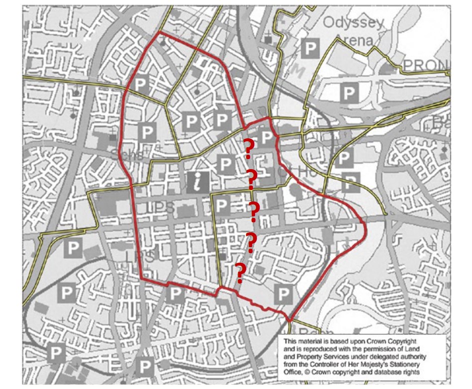
Bikefast’s big counter proposal is to double up the Primary Network around the inner core – making two concentric circles to make the options for cycling that much better than vehicle travel.

Bikefast’s proposed inner ring route – actually two inner rings
A natural street-based route is available in North and West Belfast. Something a little more visionary is available along the southern side – a future proposal in the paused Restitching Belfast Series will provide the detail – but running a cycleway from the Westlink Crossing along Roden Street, the Central Rail line, Cameron Street, a new link down to the Laganside path at the Gasworks would provide a route of exceptional utility for the city.
From here the route would follow the existing National Cycle Network to York Street railway station.
Summary
As part of an overall remedy for Belfast’s congestion ailments, the bicycle has a critical role to play in challenging the orthodoxy of vehicle travel patterns.
Around the edges of the city there is plenty of space to ensure good dedicated cycling facilities, but as a general concept we need to be pushing more cross-city journeys onto this ring road and away from the clogged middle ring and inner rings.

All of Bikefast’s proposed ring routes
This is where the stamp of the cycling network should be at it’s highest profile – taking space back from vehicles which shouldn’t have carte blanche to run through these neighbourhoods.
In the inner city the density of cycling network should be increased by creating two inner ring routes which build on existing facilities and creates new pathways – while showing we are not afraid to reduce space for vehicles.
For more information on Bikefast’s full response to the Draft Belfast Bicycle Network Plan consultation see the following articles:
- Belfast Bicycle Network Plan launched
- Dipping our toes in the Belfast Bicycle Network Plan
- Belfast Bicycle Network Plan Verdict
- Arterial Bypass: Belfast Bicycle Network Plan Objection
- Methodology: Belfast Bicycle Network Plan Objection
- Timescale: Belfast Bicycle Network Plan Objection
- Circulation: Belfast Bicycle Network Plan Objection (above)
- Isolation: Belfast Bicycle Network Plan Objection
- The last word: Belfast Bicycle Network Plan


One small coreection: the ring road is the A55; the A24 takes you from Belfast to Carryduff. The outer orbital route means the Lagan Valley Regional Park to Whiterock Community Greenway has died before being built. The orbital route already was mentioned in the BMAP as an alternative for the Greenway. I guessed at its demise when developers at Harberton Park were allowed to build a new luxury housing estate across its proposed route, despite a strip of land being earmarked for developing a path from Harberton Park to the Lisburn Road south of Kings Hall.
[…] Circulation: Belfast Bicycle Network Plan Objection […]